
The Difference is in Our Pilots
Lone Star ISR Pilots come from a diverse background of Military Veterans, Fixed Wing Pilots, First Responders, Public Safety Experts, Real Estate Professionals, Journalists and Hunters that focus on the science of conservation and stewardship of the lands. This professional diversity is how Lone Star ISR delivers results to the client.

In this Case Study, we will examine how Lone Star ISR Pilots used drones reduces chances of injury to people and animals in the Texas Hill Country.
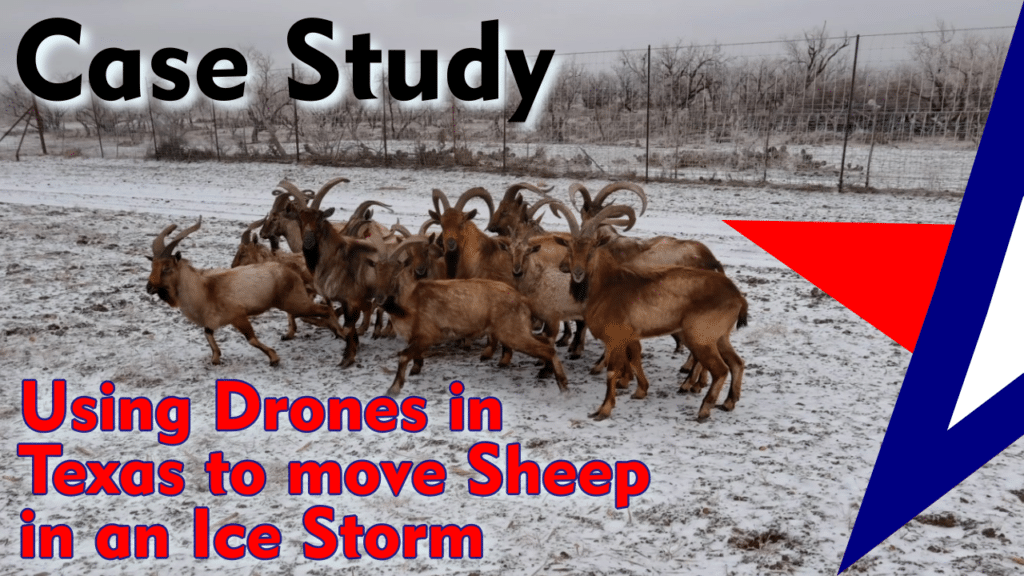
When an Ice Storm hits a Texas Exotic Game Ranch, Lone Star ISR Pilots responded to help relocate Urial Mountain Sheep from a baren pasture to one with food and water facilities in this Case Study.

This Case Study examines how Lone Star ISR’s pilots acquired Emergency Certificates of Waiver and Authorization in Class D Airspace to help locate twin brothers that drown in Galveston.

Regulatory Compliance
All Lone Star ISR’s Pilots are professionals, tested by the Federal Aviation Administration, under 14 CFR part 61 (sport, private, or commercial aircraft pilot) and/or a 14 CFR part 107 (small unmanned aircraft system or UAS pilot) certificate to conduct flight operations in the National Airspace of the United States and its territories.
Read more about Lone Star ISR’s compliance with all Federal and State Laws and Regulations.

Security Compliance

All Lone Star ISR pilots have been vetted by the Transportation Security Administration. This pre-screening allows for rapid approval of waiver applications to fly in and around locations determined to be sensitive to the security of the United States. Prior to hiring, Pilots must hold at least a “TWIC Card”, issued by the United States Department of Homeland Security. The Credential Identification Number is also a Known Traveler Number, and allows for the FAA to rapidly identify waiver applicants and approve Certificates of Authorization and Waivers filed by Lone Star ISR.
Certificates of Authorization or Waiver (COA’s) that must be acquired to fly in Class A through D, restricted National Airspace. With an approved COA, Lone Star ISR Pilots can fly in and around the following special air spaces:

Wildlife Management
Lone Star ISR’s Pilots are permitted to fly in proximity to and over privately owned Ranches and Public Lands where Native Animal Species, Domestic Wildlife and Exotic Livestock live. Lone Star ISR holds an Aerial Wildlife Management Permit issued by the Texas Parks and Wildlife Department. This permit allows for Lone Star ISR Pilots to conduct the following operations:
- Perform Census Counts (Aerial Surveys) of Native Wildlife populations
- Perform Census Counts of Exotic Livestock populations
- Conduct Predation Threat Analysis to Native Wildlife and Exotic Livestock
- Conduct Analysis of Damage to Lands and Crops by Feral Hogs
- Work with Hunters and Trappers to hunt and remove animals that pose a danger or risk to Land, Water, Human Life, Wildlife, Livestock, Domestic Animals and Crops in Texas. This includes Bobcats, Coyotes, Coyote/Dog Crosses, Feral Hogs, Red Foxes, and most Exotic Animals, excluding those protected under federal law.
Note: Lone Star ISR vehemently disagrees with the Texas Parks and Wildlife Department, interpretation that an Aerial Wildlife Management Permit is necessary to photograph, wildlife in Texas. The owners of the company believe this is a violation of the 1st Amendment to the United States Constitution. It is for this reason that that the owners provide the following link to the Order in Case 1:19-cv-00946-RP, National Press Photographers Association, Texas Press Photographers Association and Joseph Pappalardo vs Steven McCraw, in his official capacity as Director of Texas Department of Public Safety; Dwight Mathis, in his official capacity as Chief of the Texas Highway Patrol; and Wes Mau, in his official capacity as District Attorney of Hays County, Texas.

Real Estate and Property Tax Services
Drones are replacing fixed wing aircraft for the purposes of mapping, surveying and performing pre-purchase due diligence in real estate transactions and intra-construction phases of commercial construction. Lone Star ISR Pilots work with Land Agents, Land Surveyors and Licensed Property Tax Consultants to perform Analysis and/or Verification of land performance at an accuracy of 1/3,500th of a Foot, or just 1 Centimeter using LIDAR, Thermography Cameras and Visual Cameras to perform Photogrammetry to build Point Clouds and Orthomosaic Maps.
Example: Pre-Transaction Due Diligence
A Seller or Seller’s Agent represents to a potential Buyer that a long-held subject property located in the Texas Hill Country is 4,500 acres with multiple natural water sources, 225 acres of impounded water in lakes and streams behind dams, contains 445 head of Cattle, more than 900 Whitetail Deer, 125 Bison and does not have any environmental risks.
Read further how Lone Star ISR can perform verification of the Sellers claims to the Buyer.
Example: Collection of Exhibits Needed to Apply for Agricultural Property Tax Exemptions in Texas
A 1,250-acre Ranch Owner in Central Texas disputes the amount of Timber to Non-Timber land on his property with the Agriculture Extension Agent. Additionally, the Ag Extension Agent disputes the erosion control methods implemented by the Rancher on water flowing through his property. Wildlife management is defined as actively using land that, at the time the wildlife-management use began, was appraised as qualified open-space or timber land under Tax Code, Chapter 23, Subchapter D or E, to propagate a sustaining breeding, migrating or wintering population of indigenous wild animals for human use, including food, medicine, or recreation, in at least three of the following ways: (1) habitat control; (2) erosion control; (3) predator control; (4) providing supplemental supplies of water; (5) providing supplement supplies of food; (6) providing shelters; and (7) making census counts to determine population. Read further how Lone Star ISR can help the Rancher demonstrate effective erosion control methods, and conducting census counts of wildlife and non-exotic livestock on his property.
Case Study: Changes in Community Amenities Caused Home Values to Fall While Property Taxes Increased
The home owners in a former, now-defunct, PGA-rated, golf course community engaged Lone Star ISR and M. M. Mason and Co, LLC to perform aerial mapping of the former golf course and levee to demonstrate the loss of the golf course and the lake as amenities of Columbia Lakes. Utilizing open source mapping and cloud -based flight planning tools like Litchi, Lone Star ISR’s pilots collected photogrammetry images and processed them via the WebODM Lightning Cloud to produce orthomosaic images in the GeoTIFF format. Lone Star ISR merged Brazoria County’s ESRI geographic shapefile data, Google Earth imagery, with Lone Star ISR’s GeoTIFF imagery into QGIS Desktop to produce reports demonstrating the loss of amenities in the community.